
Notes from the messy middle of local government modernization.
For most of my 30+ year career, I assumed GIS was perched on the edge of a grand evolutionary leap. The sort of leap that would reveal itself any day now, provided we all stared earnestly at the technology horizon and maintained adequate optimism.
I’ve talked about this leap often. I made slide decks about it. I occasionally cornered unsuspecting department heads during meetings that had been scheduled for completely different reasons.
But after two years spent rebuilding how two rural counties use data, AI, automation, and workflows, I have reached a less cinematic conclusion. The issue was never the people. It was the framework that quietly shaped what those people were expected to do.
Traditional GIS structures were built for a world that has already moved on.
Nothing is broken. The world simply kept spinning while the GIS job description waited patiently for it to come back around.
1. The Mission Expanded While the Structure Stayed the Same
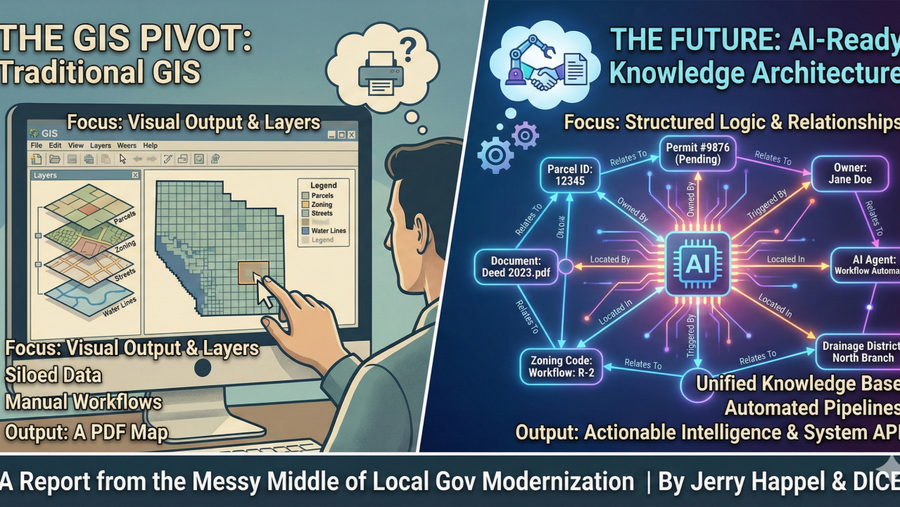
Most GIS departments, ours included, were built around a pleasantly tidy mission: create accurate maps, maintain spatial layers, support planning and equalization, and occasionally produce visuals that made a planning commission nod with the comforting sense that the universe roughly made sense.
Now, modernization arrives with a very different to-do list:
- How do we build a county-wide Knowledge Base that is actually authoritative?
- How do we make vendor systems converse without diplomatic mediation?
- How do staff search for meaning, not just for location?
GIS gave us strong spatial instincts. The future requires something closer to logic stewardship. A parcel map shows boundaries, but it rarely explains how those parcels connect to drainage districts, permit histories, organizational decisions, or that one zoning ruling from 1993 that resurfaces in meetings out of force of habit.
2. We Eventually Realized We Were Sitting in the Wrong Room
GIS traditionally lived in Planning or Equalization. Occasionally IT, if the season was favorable. These were respectable neighborhoods, although not the places where counties typically debate enterprise data standards, workflow engineering, system architecture, or cross-department governance.
In Van Buren County, our current parcel split workflow automation project makes this painfully clear. The issue is not spatial. It’s procedural. Logic is scattered through emails, scanned deeds, handwritten notes, unrecorded exceptions, and a few practices maintained largely because no one has the heart to question them. You can fix a topology error with a buffer. You cannot fix an undocumented exception with one.
GIS is often the most data-savvy group in the building yet also the least empowered to influence how the business actually worked.
3. From Interface Thinking to Architecture Thinking
For decades, GIS rewarded mastery of interfaces: geoprocessing tools, symbology, layouts, clever joins, and neat layers. These skills still matter. They simply do not unlock modern systems. AI does not interpret symbology. It interprets structure, relationships, meaning.
To extend GIS into AI and automation, we need to answer architectural questions:
- What schema ties everything together?
- How do five vendor systems communicate without a summit?
- Where should geography live inside a database designed for reasoning rather than display?
Esri produces skilled operators. Modernization requires architects. The distinction is sharp. The map is a product. The schema is the system. This shift was always coming. It simply arrived sooner than most of us expected.
4. Why We Are Pivoting
Future thinking local governments are reorganizing around four core capabilities:
- Clean, structured, unified data
- AI-ready knowledge frameworks
- Automated workflows that remove guesswork
- Governance models that span entire organizations
Spatial data remains essential. It is simply one dimension within a wider constellation of meaning. The map has not vanished. It has joined a bigger system.
5. Role Clarity (The Hard Part)
Our GIS professionals are talented, dedicated, and unreasonably fast. They can resolve a layer mismatch before most people locate the coffee filters. But building AI pipelines, designing schema, and orchestrating automation requires a different set of tools.
Some GIS staff are energized by the shift. They are learning SQL, exploring ontologies, and embracing data architecture. For them, this moment feels like career rocket fuel. Others prefer to deepen their geospatial practice without carrying the added weight of AI design or workflow engineering. This is both reasonable and respected.
My misunderstanding was assuming that GIS should automatically lead modernization simply because GIS works with data and maintains the closest thing to a knowledge graph local government has. However, proximity rarely guarantees suitability. Anyone who has sat next to a malfunctioning plotter can testify to this.
So we separated the roles. GIS remains crucial, only no longer the gravitational center.
6. What This Means for Our Teams
GIS is becoming the spatial arm of our broader Knowledge Architecture. Those who want to grow into the new work are learning SQL, workflow design, interoperability, semantic modeling, PostGIS-first thinking, and how AI systems reason. Those who remain focused on geospatial work continue to play a vital role. Spatial thinking does not shrink. It integrates.
7. The New Structure: Digital Information
We kept the GIS people. We just changed the scaffolding around them. In St. Joseph and Van Buren Counties, we are building a Digital Information Department supported by a regional shared-service entity called DICE. This structure will allow us to work from a unified regional data model, maintain an AI-ready knowledge graph, coordinate governance, and embed automation into daily operations.
8. Why We Built DICE
Most GIS folks can’t pull this off alone. Small rural counties cannot each hire a data engineer, a workflow architect, and an AI lead. The math is uncooperative on that point. A regional model, however, makes the math friendlier. DICE lets counties share the talent, infrastructure, and architecture they could not sustain alone. A single GIS office might struggle to adapt to the AI era. A shared regional structure has a stronger chance.
Final Thought
GIS is not being diminished. It is being repositioned within a larger constellation of disciplines that shape how local government understands and uses information.
The field is not disappearing. It is unfolding.
The work ahead looks less like cartography and more like constructing the conceptual scaffolding that supports every modern county function.
And that scaffolding is what we are trying to build now.
Note: Let me know your thoughts. I always want to hear different perspectives. Do you see this as the right direction or am I totally off-base? I don’t pretend to be the expert here (none of us are).